Could Geofencing be the Key to Greener and More Efficient Shipping?
In a time when industries are prioritising eco-friendly practices and operational efficiency, the Port of Rotterdam has set an impressive precedent. Their recent launch of a geofencing system as part of the Just-in-Time (JIT) Sailing project promises transformative effects on ship traffic management, fuel efficiency, and CO2 emissions. But what exactly does geofencing entail, and how does it reshape traditional shipping practices?
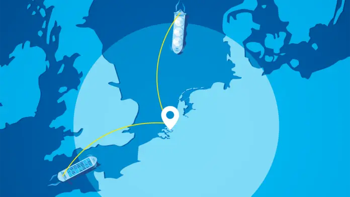
As the world’s demand for trade increases, ports face mounting challenges in managing ship traffic efficiently. Port delays, fuel wastage, and emissions have historically been tough to combat, leading the Port of Rotterdam to embark on an ambitious solution. The geofencing system, activated this October, is designed to notify terminal planners and shipping agents as vessels approach a designated boundary, or “geofence,” 240 nautical miles from Rotterdam’s Maascenter buoy.
This technological advance assigns each vessel an Actual Time of Arrival (ATA), allowing for more precise scheduling, reduced waiting times, and lower emissions. This piece will delve into how Rotterdam’s new geofencing system works, its broader implications for sustainable shipping, and why it stands as a promising example for global port operations.
The Just-in-Time (JIT) Sailing Project Explained
The JIT Sailing project, developed to optimise ship arrivals and departures, aligns with both efficiency and sustainability goals. By reducing idle times and improving scheduling precision, this system supports both environmental and economic targets. Here’s how it operates:
Geofencing: What’s Behind the Technology?
Geofencing employs virtual boundaries that trigger notifications as vessels cross specific points. For Rotterdam, the boundary is set 240 nautical miles out from the Maascenter buoy. Once crossed, the system sends real-time alerts to port stakeholders, who can begin planning based on each vessel’s new ATA. This early warning system enables terminals and agents to align resources, minimising wasted time and fuel consumption.
CO2 Emission Reduction with JIT Arrivals
A 2022 study by the Global Industry Alliance to Support Low Carbon Shipping found that implementing JIT procedures in a vessel’s final 12 hours could cut fuel usage and emissions by 4.23%. These findings, part of the IMO and Norway’s GreenVoyage2050 project, underscore the potential of JIT to make shipping not only faster but significantly greener.
Advantages of Geofencing and JIT for the Port of Rotterdam
This initiative addresses three core challenges in modern port management: environmental sustainability, operational efficiency, and collaboration among key stakeholders.
Sustainability Benefits
By lowering fuel consumption, the Port of Rotterdam’s geofencing system contributes directly to emission reductions. The JIT Sailing project further strengthens this by encouraging vessels to optimise speed, reducing CO2 output during the approach phase. This approach is not just eco-friendly but also aligns with the International Maritime Organization’s (IMO) targets for a 50% reduction in maritime greenhouse gas emissions by 2050.
Enhanced Operational Efficiency
Through better scheduling enabled by ATA predictions, geofencing allows the port to streamline ship arrivals, which helps in resource allocation and reduces congestion. Ultimately, it speeds up turnaround times for vessels and alleviates bottlenecks, facilitating a smoother flow of goods and minimising idle time.
Collaborative Framework Among Stakeholders
The geofencing rollout in Rotterdam includes terminal operators, shipping agents, and nautical service providers. This partnership strengthens information-sharing, allowing for a more synchronised approach to ship management and enhancing the port’s commitment to green initiatives. When stakeholders work cohesively, the port can not only function more smoothly but also achieve higher sustainability benchmarks.
Case Study: How Rotterdam’s Geofencing Could Set a Global Standard
Consider the recent journey of a major container vessel approaching Rotterdam. Traditionally, it might have experienced delays due to inefficient scheduling or long waits at anchorage, burning unnecessary fuel and emitting excessive CO2. But with Rotterdam’s new geofencing system, the vessel crossed the virtual boundary, triggering notifications that allowed the port to adjust its scheduling in real time. The result? A near-immediate assignment of docking resources, an optimised approach speed, and a significantly shorter waiting period.
This case illustrates the potential ripple effects when technology like geofencing integrates with JIT protocols. As major ports worldwide seek solutions to tackle inefficiencies, Rotterdam’s model offers a viable framework—particularly as environmental concerns continue to press maritime operators for change.
“Geofencing in the Port of Rotterdam isn’t just a technological upgrade; it’s a proactive approach to making shipping greener, more efficient, and more collaborative.” — Port of Rotterdam Representative
Ready to explore innovative port technologies? Stay updated on the latest in sustainable shipping advancements and see how your business can adapt by subscribing to our newsletter!